Sunday, May 26, 2013

Lemon Aid for Photographers


 This weekend has been a workshop for bad weather photography

There should be no surprise that we are experiencing miserable weather this holiday weekend. This is New England and terrible weather is the population's curse and photographer's treat, but this weekend has been depressing even for those of us trying to keep the damp from our cameras. Fellow New England Photography Guild member Jim Block is even dealing with snow on the Lilacs. Crummy days are always good for getting caught up in the studio. With a show at Keene's Prime Roast Cafe and the Keene Art Walk all coming up next week, I have plenty to do, but I had to get out to try to see what I could do with, and in spite of, the weather.

Hubbard Brook Falls

Spring rains are always an obvious invitation to shoot our many waterfalls. In a few weeks the summer droughts will dry many of the
Hubbard Brook Falls
best cascades, so my first trip was to falling water. I was trying to decide where to go when I received a call from a photographer in Laconia New Hampshire asking about a image of the falls on Hubbard Brook in Chesterfield, New Hampshire. It is challenging to get to, and not freely open to the public, but it is a lovely spot when the water is high. The call made my decision and Nellie and I headed out. The falls on Hubbard Brook are actually a series of cascades and higher drops. The hike into the ravine involved bushwhacking down steep embankments, made trickier by the soaked ground, but as usual it was worth the terror. As I worked my way down along the brook, two things occurred to me. First the cold weather had swept the black flies from the forest. Second, if slipped, Nellie would be of no practical value in getting help, and I had no cell reception in the depths of the ravine. Through much care and considerable butt bouncing I made it down and out alive.


Sound of Thunder

The light was gone, but I still had one more capture to make. The night was fractured by a series of dramatic thunderstorms and I was able to record about 40 minutes of the action on my Zoom H2n field recorder. I have started to collect natural sounds as background for my slide shows. Check out the pasture melodies on my web site front page and the thunder storm on my Summer slide show. 

To the Dump

On Saturday I was able to excite Nellie with one of the few phrases she actually understands, "Want to go to Dump?" Dump, Walk and
Pasture Corner, Roads End Farm
Dinner, that's about it. The weather remained cold damp and blustery, but we still made our regular circle through Roads End Farm. The horses were way off in the back pasture, but the rain had freshened the spring leaves along the fields. By afternoon I had to get out of the house and went into Keene to plant myself with a cup of coffee at Brewbackers Cafe. Brewbackers is usually bustling, but for some reason I find it the perfect place to write. I settle in with my iPad and my own music selection and can usually get more done in an hour than in an afternoon with the distractions at home. 


Infrared in the Rain

Central Square Gazebo


As the afternoon progress the sky grew darker, but I had a plan and I had my Infrared camera. The great thing about infrared photography is that the images are not much affected by extremes of weather. Bright, impossibly contrasty, midday light ignites the infrared spectrum. The leaves shine and the sky stays black as ink. At the other end, dull flat light still comes through with good contrast between bright foliage and dark trunks and structures. I ended up spending time shooting around Keene's iconic Central Square. I have photographed the square countless time before, but Infrared provides a whole new perspective. 


Ladies Wildwood

Wildwood Depths
I was loosing light but there was one other place that I thought might do well with the soft light. Ladies Wildwood Park is a surprising treasure in the middle of Keene. In 1890 the park was created to protect a stately grove of trees from development. The original grove was leveled in the 1938 Hurricane, but it has been replace by ranks of tall White and Red Pines.
Infrared Park
The park is small but in the right spots you can feel enveloped by the forest. The challenged is to find the angles to look through the pines without catching glimpses of the surrounding houses and roads. The flat light was great to capture the brooding mood of the pines on a carpet of nearly iridescent green. Infrared also worked well, contrasting the bright ground cover with the towering dark pillars. Light gone. Time to go home. 


Remembering 

Today Nellie and I visited the flag bedecked Spofford Cemetery. Nellie wandered respectfully among the stones and then honored the fallen by doing her business off in the woods. I grabbed a couple of flower images in the soft light, but then disaster struck. The sun actually broke through.


Disappointing. Nothing to do but go home, edit images and write this article. My only consolation is that, this is New England, and the good weather can't last forever.

Jeffrey Newcomer
Partridgebrookreflections.com

Sunday, May 19, 2013

Taming the HDR Beast

HDR ..................................................................................Blending


HDR Blending
I have never been a big fan of heavily tone-mapped HDR images, but I appreciate that it is all a matter of taste. I frequently use various post processing techniques to expand the dynamic range of my pictures, but I draw my personal line somewhat short of "cartoonish", “painterly” processing. I want my viewers to see the image as I saw the scene and, at most, ask “Did you use HDR?” and not exclaim “WOW, you really used HDR”. When using HDR programs such as Photomatix or Photoshop’s HDR Pro, I often struggle to keep the effects under control and I find that a level of tone-mapping that works well in one part of the image may be over the top in another. Increasingly I have been using image blending to manage my HDR work. The techniques are simple and provide almost infinite control over the impact of HDR and tone-mapping. 


Enhancing the Depth
Last week I got out early to catch the effect of the morning fog on the

Westmoreland Fog
early spring colors. In Westmoreland, NH, I found a nice composition with the hay wagon sitting expectantly in a pasture and the classic red barn seen on the hill above. The arrangement provided a nice sense of depth with the fog having a much stronger softening influence on the distant barn. I liked the image but I felt the effect would be stronger if I could enhance the crispness of the wagon. Enter tone-mapping. 


Given the soft light, high contrast was not an issue, so I had no need for HDR techniques to capture the full dynamic range. I didn’t capture multiple bracketed images, but I could enhance tonal contrast by applying tone-mapping to a single image. In Photoshop, I processed the image to get the best result using my standard techniques. I didn’t want to punch up the colors and contrast too much and thereby loose the soft feel of the mist, but I felt that objects in the foreground, especially the hay wagon, could benefit from crisper detail. After I was happy with the base picture, I duplicated

Tone-Mapped Crazy
and flattened the image and then opened it in Photoshop’s Tone-mapping tool. A full discussion of the use of this tool is beyond the scope of this article and also pretty much beyond the scope of my expertise. Suffice it to say that my usual approach is to

play around with the sliders until I feel I have a good result or become frustrated and chuck the whole thing. Typically I end up with something that is dramatic but beyond what I would generally feel comfortable with as a reasonably natural representation of the scene. At this point, instead of giving up in despair, I often use image blending to mute the tone-mapping effect. 


Tome-Mpped Layer at 25% Opacity & Masked


 In this case, I copied the tone mapped layer to the top of the layer stack of the original. Proper alignment was not a problem given that the two layers were from the same image. I then was able to adjust the opacity of the overlying tone mapped layer to get just the amount of enhance contrast that I wanted in the foreground elements. This global adjustment resulted in excessive contrast in the distant background, especially the misty barn. By painting with black on the mask layer I was able completely remove the tone-mapping effect from areas of the background enhancing the sense of depth in the image. 


Blended Image

Blending together a tone-mapped and regular image allows full control of the amount and location of the enhanced effects. Various levels of HDR/Tone-Mapping can be painted in by applying different levels of gray to the layer mask. White reveals all, but middle gray shows only a partial effect and because all the work occurs on the mask you can adjust and modify as much as you want. In this picture I used a single Tone-Mapped image but a bracketed, multi-image HDR layer works just as well. 


Scott Farm Rainbow

Scott Farm Rainbow

In another example I worked on an image from a wedding at the Scott Farm in Dummerston, Vermont.  The union was blessed by a beautiful
Over the Top
rainbow.  I captured the color with the farm and a classic truck in the foreground, but I thought the truck was a bit dull and flat.  At home, I created a tone-mapped version.  I typically go a bit heavy with the toning, since I know it will be muted in post.  Again, I modified the effect with opacity and then use a mask to apply it only to the tuck.  I had a great time adjusting the opacity to find the right amount of enhancement and I still may mute it a bit further.

Tone-Mapped Truck

So get out there and HDR your brains out.  Not to worry, you can always calm the craziness with a little gentle blending.


Jeffrey Newcomer
Partridgebrookreflections.com

Sunday, May 12, 2013

Monadnock, The Documentary Film

The Mountain That Stands Alone

"Monadnock, the Mountain that Stands Alone" will be a feature length HD Documentary with history and personal stories along with beautiful imagery and music written and composed in New Hampshire.”

 
Anyone who lives or has ever passed through the Southwestern corner of New Hampshire must be aware of the one prominent feature that identifies and defines our region. Mount Monadnock is often referred to as the mountain that stands alone. At only 3165 feet the peak is not one of the tallest in New Hampshire. In fact it just misses being included in the top one hundred, but the mountain stands more than 1000 feet higher than any peak within 30 miles in any direction. In fact geologists refer to any isolated peak, standing alone above the surrounding landscape as a "monadnock". The mountain's rocky summit offers expansive views from Mount Washington to the Buildings of downtown Boston. It is not surprising that this accessible peak is one of the most climbed in the world, but Mount Monadnock means much more to our region than merely a nice place for a hike.


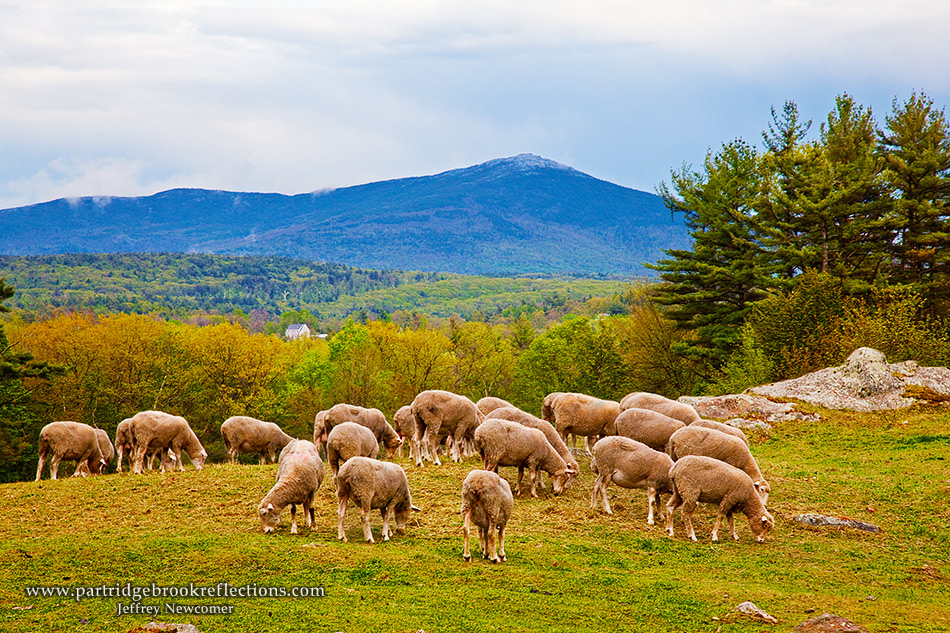
Sheridan grazing under the mountain
Mount Monadnock can be seen from everywhere in the Monadnock Region and its proud, independence has marked the philosophy and character of those who live under its gaze. Much like the mountain, the Monadnock region lies somewhat isolated from the major cities of New Hampshire and New England. As I often say, the region is drawn together by miles of bad road, in every direction. As a result, the people have always looked to each other for support and to solve their problems. Mount Monadnock has remained the perfect symbol of this “independent” interdependence. 


The mountain means something different to everyone in our region. It may seem inevitable that Monadnock should remain natural and pristine, but it was only through the intense effort and dedication of many people over centuries that Monadnock has escaped the forces of development. How our mountain has been protected in its heroic state is a great story of teamwork, persistence, and quite a bit of dumb luck. It is that unappreciated story, along with how the mountain inspires people in our own time, which will be central to the upcoming feature length documentary film, "Monadnock, the Mountain that Stands Alone". 


Over the last several years I have been privileged to watch and help, in small ways, the efforts of a dedicated core of people who have been

Steve Hooper discussing the film
working on the first documentary film about our mountain. Rabbit Ear Films is led by photographer Steve Hooper and by documentary film producer and editor, Dan White. Our script has been written by Craig Brandon, author of "Monadnock More Than a Mountain". 
Larry Siegel of Westmoreland, NH is collaborating with Rabbit Ear Films to compose music for the film based on his original composition of Monadnock Tales.  Our group has been assembling
interviews, scanning archival images, and collecting video of the
mountain in all its seasons and moods. The video has all been recorded in high definition in anticipation of the production of a 90
minute, broadcast ready, film of the highest quality. Our plan is to
Dan White Editing
Image by Steve Hooper


present the documentary at film festivals, schools and historical societies. The group also will seek presentation on PBS. My role has been to contribute video of the mountain using the High Definition Video capabilities of my Canon 5D Mark II. It has been a fascinating experience learning to make the transition from still photography to video and I have come to appreciate the special demands of videography. 

Learn more about the Crew


Author Craig Brandon and  former park manager Charlie Royce
Gaze at the Mountain

All of the work on the film has been carried out by a small group of people with a broad range of talents, but a narrow focus on producing
a film worthy of its subject. Largely working as volunteers, we have made great progress, but are now reaching the final stages; the difficult, and expensive, task of melding the visual elements with music and narrative into a coherent and compelling story. We are striving to produce a top quality film on a shoe string budget, and although we have had significant financial support from generous individuals, corporations and foundations, we are looking for a final push to get us over the top for completion by the end of this year. 


We have been sharing our vision with the community.
Here in Marlborough, NH


Top quality documentary films are not cheap. Our total budget of $150,000 is really amazingly low largely because of the volunteer work that has gone into the production. For the final $15,000 that we need to complete post-production tasks, we have decided to reach out to the community of Monadnock for “crowd funding” . Now is your opportunity to help complete this project. We have begun a fund raising campaign through Indiegogo, the world's largest global crowdfunding platform. Any help no matter how small would be greatly appreciated and donating is easy AND rewarding. We are offering some nice thank-you gifts from Mt. Monadnock Magnets and Rabbit Ear Films caps, to your name in the films credits. If you are really generous we might make you an “executive producer”.

 Please check out our Donation Page and help tell the story of our unique mountain . 


Check out our film trailer at:  Extended Trailer


The mountain is calling to you.


Jeffrey Newcomer
partridgebrookreflections.com 


Sunday, May 5, 2013

Blow-Me-Down Mill, A Welcome Photo Assignment

Blow-Me-Down Mill


Blow-Me-Down Mill in Cornish, New Hampshire is a lovely place to photograph, but what’s with the name?

I love an assignment so when Cam Mirisola, Senior Editor for New Hampshire To-Do Magazine emailed me last week about a project

Aspet House, Saint Gaudens,
Cornish, NH
for an up-coming edition, I got excited. Cam was looking for images of Cornish New Hampshire, specifically, any showing the beautiful Saint Gaudens Historic Site in the spring. I was a little disappointed that I already had pictures of the site which seemed to satisfy her request from a couple of years ago, but she also mentioned a location that was entirely new to me. At once I knew I had my assignment.
Saint Gaudens Retreat Blog

Cornish-Windsor Covered Bridge
The next day I got up early to search Cornish for the intriguingly named “Blow-Me-Down Mill”. Of course I first Goggled the mill and learned that it was now part of the Saint Gaudens National Historic Site. In the morning I cruised up Route 12a along the Connecticut

Cornish-Winsor Bridge, Mount Ascutney
River stopping at the Cornish-Windsor Covered Bridge. The bridge was completed in 1866 and spans the Connecticut between Cornish New Hampshire and Windsor, Vermont. At 449 feet, it was the longest covered bridge in the country, until 2008 when a new concrete piered bridge was opened in Ohio. Really, 2008, Concrete, Ohio? Should that count? Anyway, the Cornish-Windsor Bridge still has the longest single span that carries vehicular traffic. On Monday morning, the sky was overcast, but I always find it difficult to pass by without grabbing a few shots with Mount Ascutney in the background.

The Cornish Art Colony
My initial directions to the mill were unnecessarily vague and sent me

Cornish Colony & Mill
off along the back roads of Cornish. After a lovely exploration, I eventually circled around and found the site, right on Route 12a, just few hundred yards north of the main entrance to Saint Gaudens. There had been a mill on this site dating back to the 1820’s, but the current structure was built on the direction of Charles Beaman in 1891. Beaman, a wealthy lawyer from New York City, had built his summer retreat in Cornish in the 1880’s and was instrumental in enticing the famous sculptor August Saint-Gaudens to build his summer home and studios nearby. Saint Gaudens was one
of the founders of the Cornish Art Colony. The Colony was renowned as a seasonal gathering place for a remarkably varied group of prominent artists of the time, including painters, sculptors, writers and actors. The Blow-Me-Down Mill was used by the community as a grist mill until its close in 1920, Now, only the restored building remains, along with a nice mill pond/wet land and a water fall.

Working the Mill
The day remained mostly overcast with only early hints of spring
foliage, but the area provided a wealth of interesting angles and I had a great time exploring the various options. My first challenge was to find a place to park the car that wouldn’t intrude on the pictures.  Despite my efforts, I still had to relocate as I moved around the site. The waterfall had good flow, and with the overcast sky, I was able to get a nice soft effect with only my polarizer and f22, but I also pulled out my variable neutral density filter to extend the exposure over several second. The compositional challenge was to find angles that included a nice balance of the mill building and the falls. From the side the building was rather flat and one dimensional so I moved down stream for better
perspective. During the summer and fall with the trees in full foliage views up the brook to the mill house would be obstructed, but on this
Four Second Exposure with Variable ND Filter
day, I was able to get a clearer look. The scene taken from the Stone
Bridge offered an especially nice perspective on the whole site. Along the edge of the brook, I used my trusty Mini Bungee Cords to pull back branches and, unlike most times, I actually remembered to retrieve the cords when I was done. In most compositions, I tried to minimize the dull sky, but I was able to bring out some of the texture in post using highlight 
adjustments.

Downstream with Bungee Assist


Stone Bridge/Tunnel


Stone 'Bridge"/Tunnel HDR
Downstream from the mill is an impressive stone bridge that, with the movement of the road, is now more of a tunnel. With the bright outside and dark tunnel, it was an excellent chance to apply a little HDR. In my picture I used 7 images. It was interesting how the small water drains lit up along the passage. They looked rather strange, but I decided to leave them in.


Blow-Me-Down Covered Bridge


Blow-Me-Dow Bridge over
Blow-Me Down Brook
My “assignment “ complete, I went on to explore the Blow-Me-Down Covered Bridge, which, not surprisingly crosses the Blow-Me-Down
Brook. Seriously?!  Is everything "Blow-Me Down" in Cornish?  The bridge itself was not especially unique, but then I move off to the side and discovered that it spans a spectacular little gorge("Blow-Me-Down Gorge I presume). I could have spent much more time here, but I had to get back to town. 

All-in-all it was a productive morning given the weather and the scant early spring foliage. As always I have this place recorded in my brain and in my GPS. I will return. Whether or not something gets in New Hampshire To-Do, I still have to thank Cam for a great tip and a good excuse to get away from the endless spring chores at home.


Oh, and the name. From what I read Saint Gaudens himself picked “Blow-Me-Down” as a joke. I’m not sure about that, but it is as good an explanation as any.

 Blow-Me-Down Mill:
 43° 29' 49.806" N
 72° 22' 32.544" W


Saturday, April 27, 2013

The Galapagos Islands a Photographic Journey (Part 1)


The Galapagos Islands off the coast of Ecuador are a treasure of abudant and diverse wildlife.  For photographers, it is unlike any other place on earth.  It is not easy to get there but if you ever have a chance, don't think, just go.

This is one those weeks when I find myself desperate for a topic for the weekly blog. Actually that is true of most weeks. It is a mystery how every week something, no matter how lame, seems to come up. Of course I do try to keep a few topics in reserve for emergencies. Some have been in reserve for a long time and eventually, they scream to be let loose. So this week it is time to open the emergency file and let one of my children fly free.

Actually it is hard to believe that I have held on to this one for so

Espanol Mockingbird
long, since it is about the most remarkable photography trip I have been fortunate enough to enjoy. In December of 2010, Susan and I spent almost two weeks in Ecuador. Much of the time was spent on a photography cruise among the Galapagos Archipelago aboard the National Geographic ship the Endeavour, but we also finished the trip with several days at the Maquipucuna Reserve in the Andean cloud forest. For a landscape photographer like myself the whole trip was an immersion into an amazing diversity of wildlife.


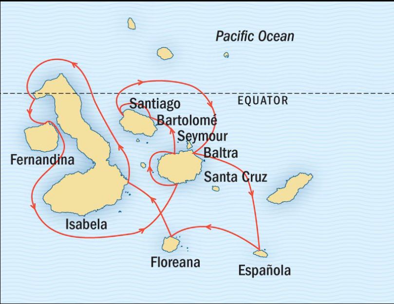
Galapagos Route
The Galapagos Islands straddle the Equator about 600 miles off the coast of Ecuador. Their isolation made them a perfect location for Charles Darwin's field observations, in the 1830's, that led to his revelations about evolutionary biology and natural selection published in his 1859 book, Origins of the Species. Since Darwin there have been intense pressures to develop the islands, but through the remarkably enlightened efforts of the Ecuadorian people the Galapagos have been largely restored and preserved. 97.5% of the Galapagos Islands are now, strictly protected, 
Nazca Booby in Flight
uninhabited park land, accessible only by licensed tours, on ships which follow tightly controlled itineraries. Everything is design to limit human impact. Travel on the islands is restricted to carefully marked walking paths and if even a toe strays across the boundaries, the ever present naturalist guides are quick to pull you back onto the path. It can be frustrating for photographers when the perfect angle on a scene is just out of bounds, but I quickly appreciated the nearly fanatic attention that is protecting this special place for generations to come. Our first inkling of the commitment to preservation came on the flight to the islands from the coastal city of Guayaquil. In the air the contents of the overhead compartments were spray with insecticide. Upon landing, and before we could touch the soil of the Galapagos, we had to walk through a basin of disinfectant.


Sea Lions on the Benches


We landed at the little airport on small island of Baltra. While waiting to get ferried to our ship, we got our first experience with the native animal’s total disregard for human activity, when we discovered that the benches were all occupied by lounging Sea Lions. Our ship was the National Geographic Endeavor, a sturdy 296 foot expedition boat that spent its earlier life exploring around the Polar Regions. The Tour was run through Lindblad Cruises.


National Geographic Endeavor,
Zodiacs were our primary mode of transportation

Our trip was a designated photography tour which meant that there were more than the usual number of photographic guides and the

Dawn Patrol
walks were paced to allow stops that were long enough to permit time to properly work the sites. Also every morning boats were provided to bring the dedicated photographers to shore just after dawn and before the sane people were even thinking about breakfast. Perhaps the best part was that many of the participants were professional photographers, but, like me, they were not primarily wildlife shooters. There were people who specialized in areas such as studio, portrait, and wedding photography, but we all shared the excitement of having the opportunity to shoot in an entirely unique environment. It was great to be exploring with such an experience group of photographers and I probably learn as much from them as the guides.

North Seymour Island
But enough travel log. I want to talk about the animals. On our first day, we got settled quickly and had time to spend a few hours 


Blue Footed Booby Dance
before sunset exploring nearby North Seymour Island. We had the chance to get close to many exotic birds, including the prancing Blue Footed Boobies, and the Majestic Frigatebirds. The Boobies are lovely in flight, but ridiculous on the ground with their famous “Booby Dance” and matting display. And their feet really are blue. Frigates have the largest ratio of wing span to body weight of any bird. They are great long distance, endurance flyers, but can’t take off from the ground. They are most famous for the ballooning red pouches which males use to attract a mate. As we walked along the path we were close enough to touch the unperturbed birds. Of course if I had reached out my hand it would have been instantaneously lopped off by one of our helpful


Frigatebird on the Make
guilds. The Sea Lions were so close that we occasionally had to step over them to continue down the trail. We could have lingered for hours but our guides were watching the time. Sunset comes quickly on the equator as the sun plummets strait down to the horizon and we wanted to get in the Zodiacs before we were lost in darkness. It was short visit, but  a great introduction to the amazing experiences to come. In the evening we had our first experience with the wonderful food on the ship while we cruised to Espanola Island, one of the southern most of the archipelago. 


North Seymour Sunset

 Blue Footed Booby Dance Video (You Tube)


Espanola 

Cliffs of Espanola


The Galapagos Islands sit above colliding tectonic plates and are
Waved Albatross
volcanic in origin. They range widely in age, with the older islands, such as Espanola, more than 3 million years old, and located to the east. To the west, the islands such as Isabela and Fernandina are still forming with the last major eruption on Ferandina in 2009. It all adds up to the wide variety of geology as well the endemic fauna. Our second day was spent exploring Espanola, which,
Albatross Chick in the Nest
because of its isolation is home to many unique species. Most notably Espanola is the only place on earth on which the beautiful Waved Albatross nests. Like the Frigate, the Waved Albatross is a famous long distant flyer, using the winds to soar and glide for hours, but they also have trouble taking off from flat ground. Albatross
Immature Nazca Booby, Espanola
prefer to nest along the high cliffs of Espanola, where their young
learn fly by leaping off the precipice, facing success or oblivion. Strolling along the cliffs we had the opportunity to study Albatross and Nazca Booby nests. While the mature birds were out fishing we were able to comfortably approach within a couple of feet of immature birds still in the nest. Espanola is also home to unique species of, red colored marine iguana and Hood Mockingbirds. In the afternoon we visited another part of the island with an entirely different feel. Gardner Bay is one of the few
Espanola Marine Iguana
expansive sandy beach in the Galapagos. Here the major attraction was scores of Sea Lions resting contentedly on the brilliant white sand. As always the Sea Lions paid no attention to the funny looking bipeds, except that occasionally a curious pup would chase us up the beach. We had to be careful to avoid touching the adorable little guys. (Check out the video below)


Gardner Bay


Sea Lion Video Montage (You Tube)

After the first couple of days days we were all thrilled and exhausted. It is such a privilege to have the opportunity to explore the Galapagos that I didn't want to waste a moment and from dawn to dusk the expedition guides provided a continuous flow of activities to keep us moving. In addition to our tours on land we generally had one or two chances

Green Sea Turtle
every day to snorkel in the rich underwater world that thrives around the islands. Sadly I wasn't prepared for underwater photography, but the experience was remarkable. We swam leisurely among swarms of riotously colored fish as well as Green Sea Turtles, Galapagos Penguins, Sea Lions and Black Tip Sharks. On one occasion I found myself face to face with a Sea Lion who had just captured a fish. He identified me as a competitor and nailed me with a jealous stare. I moved away.

Sally Lightfoot Crabs


Black Necked Stilt
Floreana
Our third day was spent at the southern island of Floreana. After a morning snorkel we hiked to an isolated beach populated by lounging Sea Lions and the brightly colored Lady Lightfoot Crabs. Throughout the islands, these brilliantly red creatures contrast with the stark gray and black of the lava rocks. Inland on Floreana is a large salt water pond that is the surprising home of a flock of flamingos as well as the delicate appearing Black-Necked Stilt.


Nazca Booby on Espanola
This is probably a reasonable point to pause. Even a superficial description of our trip deserves more than one article. If you are still with me, check back next week for more, including migrating Giant Tortoises, the Galapaos Hawk , Gray Pellicans and more remarkable landscape. Yes I actually got to shoot a little landscape!

For More Images Check out:
Check out Galapagos Journey Part 2 for the completion of the story.


    Jeffrey Newcomer
    Partridgebrookreflections.com